
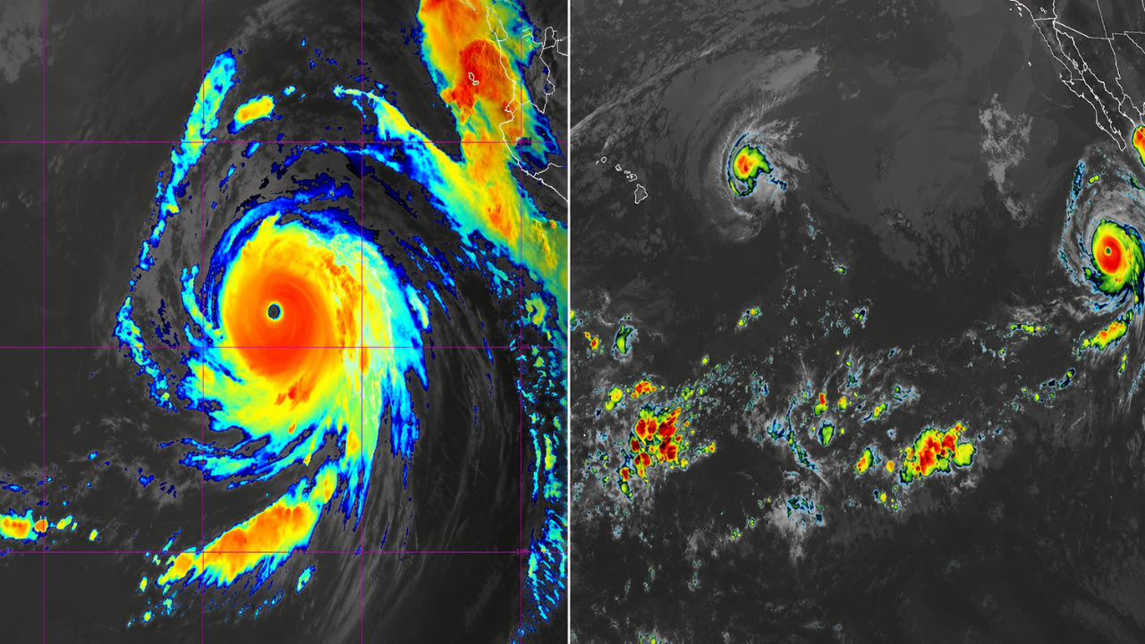
Hurricane Genevieve, which apparently has become a strong Category 5 hurricane with maximum sustained winds near 160 mph, is being kept in a wary eye by meteorologists and residents along the eastern Pacific coasts. Forecasters say the storm is expected to stay well offshore but could still produce dangerous ocean conditions, including large swells that could produce waves as high as 11 feet along portions of Southern California later in the week. As hurricane forecasts can change rapidly, readers are advised to follow official updates from the National Hurricane Centre (NHC) and the National Weather Service (NWS).
Hurricane Genevieve is now a weather story to watch closely, but not for a direct landfall threat. Rather, the dangerous surf, strong rip currents and high wave action are expected to impact beaches far away from the storm’s centre.
Genevieve gaining strength in eastern Pacific
Genevieve has strengthened into a major hurricane churning over warm Pacific waters, forecast discussions say. A hurricane of this magnitude can generate long-period swells that can travel long distances across the ocean even when the cyclone is hundreds of miles offshore.
Current forecasts show that the storm will remain over water, reducing the threat of direct impacts on populated coastal areas. But even if the hurricane doesn’t make landfall, its strong winds can create large ocean swells that could reach from beaches in Baja California to Southern California.
Meteorologists continue to track the hurricane’s track, intensity and any changes that could affect expected coastal conditions.
Get Ready for High Surf and Dangerous Rip Currents
Indeed, the biggest threat to Southern California may be not destructive hurricane-force winds but dangerous surf. “Long-period swells from Genevieve could produce waves up to 11 feet high on some of the more exposed beaches, especially where local terrain helps amplify the surf.
Large waves can generate hazardous rip currents that threaten swimmers in the water. Even the best swimmers can get caught in fast moving currents in big swell events.
Large waves can also impact harbour entrances, rocky shorelines and coastal jetties, increasing the risk of boating and shoreline activities.
Southern California residents have to heed government warnings.
When waves start moving closer to shore and conditions become more hazardous, local emergency officials and weather agencies may issue beach hazard statements or high surf advisories.
Residents and visitors should check with the National Weather Service, local emergency management offices and lifeguard advisories prior to entering the water. Inland skies may be clear but the incoming swell can change conditions quickly.
Anyone planning to surf, boat, fish or go to the beach should take extra care and stay away from places where waves are breaking over rocks, piers or coastal roads.
How Far Away Hurricanes Can Impact the California Coast
Most people think of hurricanes in terms of direct landfalls, but strong Pacific storms often can affect conditions thousands of miles away along the coast.
Large hurricanes are responsible for producing long period ocean swells, which travel efficiently across open water to distant coastal shores. Even if the storm stays out at sea, those swells can create bigger waves, stronger currents and more beach erosion when they reach California’s coast.
That’s why meteorologists keep a close eye on eastern Pacific hurricanes, especially during hurricane season.
Forecasts Are Subject to Change
Several times a day, new observations are taken from satellites and aircraft and the newest computer models are run – all providing updated hurricane forecasts.
Genevieve is expected to remain offshore for now but any change in its strength, track or speed forward could impact the timing and size of incoming swells. So members of coastal communities should check the latest official forecasts, not older reports circulating online.
Even if the hurricane weakens before it reaches cooler waters, swells already generated by the storm could continue to propagate towards the California coast for days.
Sources
- National Hurricane Centre (NHC) – Official hurricane advisories, forecast tracks and storm intensity updates
- National Weather Service (NWS) – Coastal hazard statements, high surf advisories, marine forecasts and local weather
- NOAA – Hurricane Science, Weather Forecasts, Marine Observations & Ocean Monitoring.
- California Governor’s Office of Emergency Services (Cal OES) – Safety tips and emergency preparedness information to know before heading out on the water.
- Associated Press – Reports of major weather events & emergency situations confirmed
- The Weather Channel – Forecasting, coverage of hurricanes and coastal impact reporting