

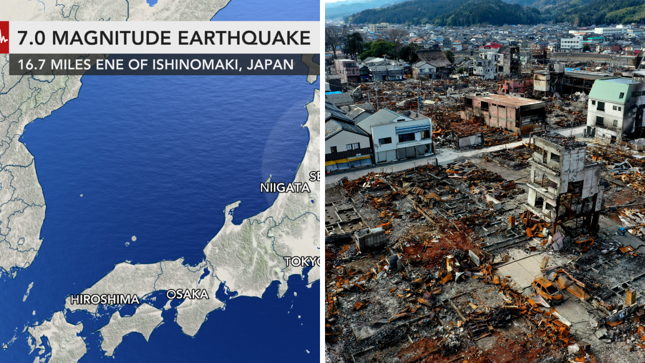
Emergency officials are still assessing the damage from a strong earthquake in Japan. Teams are trying to collect information on damage, infrastructure and public safety disruptions. Seismic charts and maps assist officials in gauging the scope of the earthquake and are directing rescue and recovery operations. Inspections are ongoing and it may be some time before the full extent of the event is known.
Monitor the effects of the Japan earthquake with seismic intensity maps, satellite images, aftershock tracking and local damage reports. Government agencies and scientific organisations are keeping the public informed as new information becomes available, so residents and emergency responders can make good decisions during the recovery process.”
Seismic maps – most affected areas
Japanese weather and disaster management agencies released seismic intensity maps showing areas that experienced the strongest shaking following the earthquake.
The maps can pinpoint where the ground moved the most allowing emergency services to focus their inspections and help on those areas. The epicentre is the point where the earthquake starts but the strongest shaking can be felt over a much wider area, depending on the geology.
These maps are updated regularly as new measurements are provided by more monitoring stations.
Damage Assessments Underway In Several Areas
Buildings, roads, bridges, railways and utilities are being inspected for structural damage.
In many earthquakes, initial reports tend to concentrate on large infrastructure, while detailed inspections of homes, schools, hospitals, and commercial buildings continue for several days afterwards. Engineers determine if buildings are safe enough for people to live in, or if they need repairs before people can return to them.
Officials warned residents to be on the lookout for damaged roads, unstable buildings and other hazards that may not be readily visible.
There is a big concern of aftershocks
After a major quake, you expect aftershocks and they can continue for days or weeks.
Most aftershocks are smaller than the main earthquake, but they can cause more damage to already weakened buildings, and can slow recovery. Emergency agencies typically advise residents to prepare for aftershocks and to follow official safety advisories.
Japan’s extensive network of earthquake detection systems is allowing seismologists to closely track the aftershock activity.
Disruption of transportation and public services
Transportation systems, including rail service, highways, airports and local roads, are often damaged by earthquakes.
Train lines, bridges and tunnels are normally safety-checked before they reopen. Utility providers also examine the electricity, water, gas and telecommunications infrastructure to find outages and get essential services back up and running as soon as they can.
Work is ongoing but there may be temporary service outages in some areas for repairs and safety checks.
Emergency Response and Recovery Operations
Local authorities, emergency services and national agencies have been mobilised to assist the affected communities.
Search and rescue, short-term shelter, medical aid and distribution of emergency supplies to where they are needed are often part of response activities. Officials also hope to keep lines of communication open with residents by providing timely updates on evacuation guidance, transportation and weather conditions that could impact recovery.
As more detailed assessments become available, recovery efforts are likely to change.
Scientific Data Explains Earthquakes
Today earthquake monitoring comprises the use of seismic stations, satellite observations and geological analysis in order to better understand how an earthquake took place.
Scientists use this information to estimate the earthquake’s magnitude, depth, fault movement, and distribution of ground shaking, among other things. The findings should help emergency planning and future earthquake preparedness and engineering standards.”
Japan has one of the most advanced earthquake monitoring networks in the world, and it provides a lot of real-time information about seismic activity.
Officials are continuing to monitor the situation
Maps and charts are beginning to create a clearer picture of the impact of the earthquake, but officials warn assessments could change as inspections continue.
Residents are asked to stay tuned to official government announcements for updates on aftershocks, transportation, utility restoration, evacuation and safety recommendations. New maps and confirmed damage reports are helping to give a clearer picture of the overall impacts of the earthquake and recovery is underway.
Sources
- Japan Meteorological Agency (JMA) – Official earthquake info, seismic intensity maps, aftershock updates, tsunami alerts.
- Japan Cabinet Office – Disaster Management, Emergency Response and Recovery
- United States Geological Survey (USGS) – earthquake information, magnitudes, epicentre maps and scientific analysis.
- Reuters – Earthquake news, rescue efforts, official statements.
- AP – covering disaster response, infrastructure damage, and recovery efforts.