
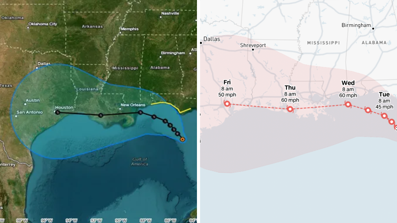
Tropical Storm Bertha is in the news as forecasters watch its possible track and impacts along parts of the Gulf Coast. Forecast models can change with new data, but meteorologists are monitoring the system closely for possible heavy rainfall, gusty winds, rough surf and localised flooding across Florida, Louisiana, Texas and others.
If you are in the Gulf Coast, continue to monitor the National Hurricane Centre (NHC) and local weather offices for updates. Tropical systems can change direction and get stronger quickly with little warning.
Forecast tracks keep changing
“The future track of Tropical Storm Bertha is still uncertain, and will be dependent on atmospheric conditions, sea surface temperatures and steering winds, according to the latest forecasts. Meteorologists say forecast cones and rainfall outlooks are routinely updated as new satellite observations and computer models come in.
Forecast guidance could show parts of Florida, Louisiana and Texas as areas to watch, but the location of the strongest impacts could shift before landfall or as the storm moves across the Gulf region.
So residents should not only focus on the centre of the forecast track, but should prepare for possible impacts over a broader area.
Heavy rain and flooding may pose the biggest threat
Heavy rain is often one of the most dangerous hazards from tropical systems, regardless of the exact path of the storm. Slow moving storms can produce heavy rainfall amounts which increases the threat for flash flooding, urban flooding and rising water in low lying areas.”
Motorists should avoid flooded roadways, and shallow water can be dangerous. Local emergency management officials may issue flood watches or warnings if rain rates increase.
When a storm is coming, communities that have been flooded before should be especially alert.
Possible Gusty Winds, Rough Surf Along Coast
Tropical storm Bertha could bring gusty winds, along with heavy rain that could bring down tree limbs, cause scattered power outages and make travel difficult. Coastal communities also could see hazardous surf, rip currents and higher than normal tides.
It’s a good idea for boaters to pay attention to marine forecasts and consider staying in port if things look dicey. Beachgoers should heed local safety advice as rip currents can be deadly long before the storm makes landfall.
Louisiana, Texas and Florida Need To Watch For Official Updates
Emergency management agencies along the Gulf Coast routinely monitor tropical systems and provide guidance as things change. “Folks in Florida, Louisiana and Texas need to check their emergency plans, ensure they have basic disaster supplies and be poised for shifting forecasts.
Weather experts, however, say the best place to get official information is social media, where forecasts are updated frequently as new observations come in.
It is always a good idea to prepare for severe weather before any watches or warnings are issued.
Expect the forecast to change
As the tropical systems approach land confidence in the forecast will generally increase and updates will be provided on a regular basis. Residents should continue to monitor reliable weather agencies for the latest track forecasts and rainfall outlooks and any watches or warnings that may be issued.
What Tropical Storm Bertha will do in the end will depend on how it develops and where it goes in the coming days, but the best way to mitigate risk during hurricane season is to stay informed and stay prepared.
Sources
- NHC (National Hurricane Centre) – Tropical Cyclone Advisories, Warnings, Track Maps & Official Forecasts from the NHC
- National Weather Service (NWS) – The NWS provides local weather forecast, severe weather and flood warnings
- NOAA offers hurricane outlooks, satellite observations and tropical weather research.
- Reuters – Reuters reports on major weather events, emergency response and official government updates.
- The Weather Channel – The Weather Channel offers forecasts, radar images, storm coverage, and analysis based on official meteorological data.